| |
Cadworld works with European and North American prime
contractors as their offshore business partner, providing
high-quality digital photogrammetry services.
We help you beat the competition. Without becoming your
competition.
| :: |
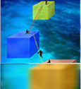
Aero Triangulation View
Projects |
 |
| |
We can provide a complete AT solution for you, including
Block set-up, Bridging & Bundle Adjustment .
Output can be provided in all standard formats such
as PAT-B and ZI Imaging project file format.
|
|
| :: |
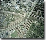
3D Planimetric collection
View
Projects |
|
| |
We can extract planimetric surface features such
as
 Transportation (roads, railroads, sidewalks, parking
, driveways, ….)
Transportation (roads, railroads, sidewalks, parking
, driveways, ….)
Hydrography ( rivers, streams, canals,ditches, ponds,
lakes, sea shore . )
Hypsography (breaklines, contours, spot heights,
masspoints)
Structures ( buildings classification, walls, fencing,
bridges, airports …..)
Utilities ( lightposts, roadsigns, manholes, transmission
towers, power lines,water
and gas lines, hydrants …..)
Cadastral ( plot boundaries )
Accuracies will meet or exceed your standards,
including NMAS, ASPRS , TKGIS or any other
standard as requested. Digital output can be supplied
in most of the popular vector formats including
dgn , dxf ,shp and will conform to your layering
standards.
|
|
| :: |
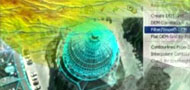
3D Topographic collection
– DTM / DEM / Contours View
Projects |
|
| |
Topographic features, contours and spot heights
can be precisely extracted.
For support to digital orthophotos or small-scale
maps, Cadworld uses photogrammetric data collection
to generate GRID datasets from Masspoints, prominent
ground features and breaklines representing the
terrain in a 3D model space.
For contour generation in large-scale maps,
masspoints, breaklines and ground features
are collected and processed in specialized software
to create Triangulated Irregular Networks
(TIN) or wire frame representations. Digital Terrain
Models are then generated from this data. Contours
can be generated up to 1 foot intervals.
Output can be supplied in ASCII or vector
formats.
|
|
| :: |
3D Urban modeling View
Projects |
|
| |
We specialize in developing 3-D models of complex
urban structures at the city level. Used for
applications such as urban design, urban planning
and mobile telephony planning, such projects
require a high degree of
multi-functional skills in Photogrammetry, Computer
Aided Design / Drafting
(CADD) and Architecture.
Cadworld brings together an unique team of
skilled architects, CADD professionals and
photogrammetrists, which gives us the rare capability
to create highly accurate 3D models of entire
cities from aerial photos.
Accuracies of up to +/- 10 cms have been achieved.
|
|
| :: |
3D telecom datasets
View Projects
|
|
| |
3D building datasets, clutter data and street
coverages can be precisely generated by us for
use in cellular telephony Radio Frequency planning
tools. Vector output can be formatted for easy
conversion to ASCII datasets.
|
|
| :: |
Edit and map finishing |
|
| |
Our team of skilled GIS technicians will carry
out a full map edit of the photogrammetric output,
including cleanup, editing, edge matching, tiling
and mapsheet generation.
|
|
| :: |
Ortho Rectification
View
Projects |
|
| |
We can produce sharp and accurately color-balanced,
seamless, map-quality ortho-imagery in any projection
format as requested..
We are experienced at carrying out all the tasks
in the ortho production workflow :
Image adjustment and dodging
Import / preparation of DTM and TIN
Orthorectification
Seamline generation
Mosaicking
Final radiometric adjustments
Tiling
Touchup for hair and dust removal
Patching orthos for bridges and overground features.
|
|
|
|